

Chris_w
-
Posts
43 -
Joined
-
Last visited
Content Type
Profiles
Forums
Resource Library
Events
Gallery
Blogs
Store
Community Map
Posts posted by Chris_w
-
-
Thanks. However, it’s not another Britain from the Air photo. There aren’t a huge number of those and most are limited to NI. The best source of other aerial photos is found on the website of the National Library of Ireland. I think I’ve only found ~4 aerial photos from BfA. Most of the rest are NLI. There are also some newspaper ones (based in Belfast) - can’t remember the name off hand.
-
LOCATION SOLVED………

-
 1
1
-
-
Hi, would you be willing to share them online or privately?
-
Maybe….
Done some drawing / photo comparisons…. What do you think?
Close up of track drawing….
-
On 7/7/2021 at 11:34 AM, Chris_w said:
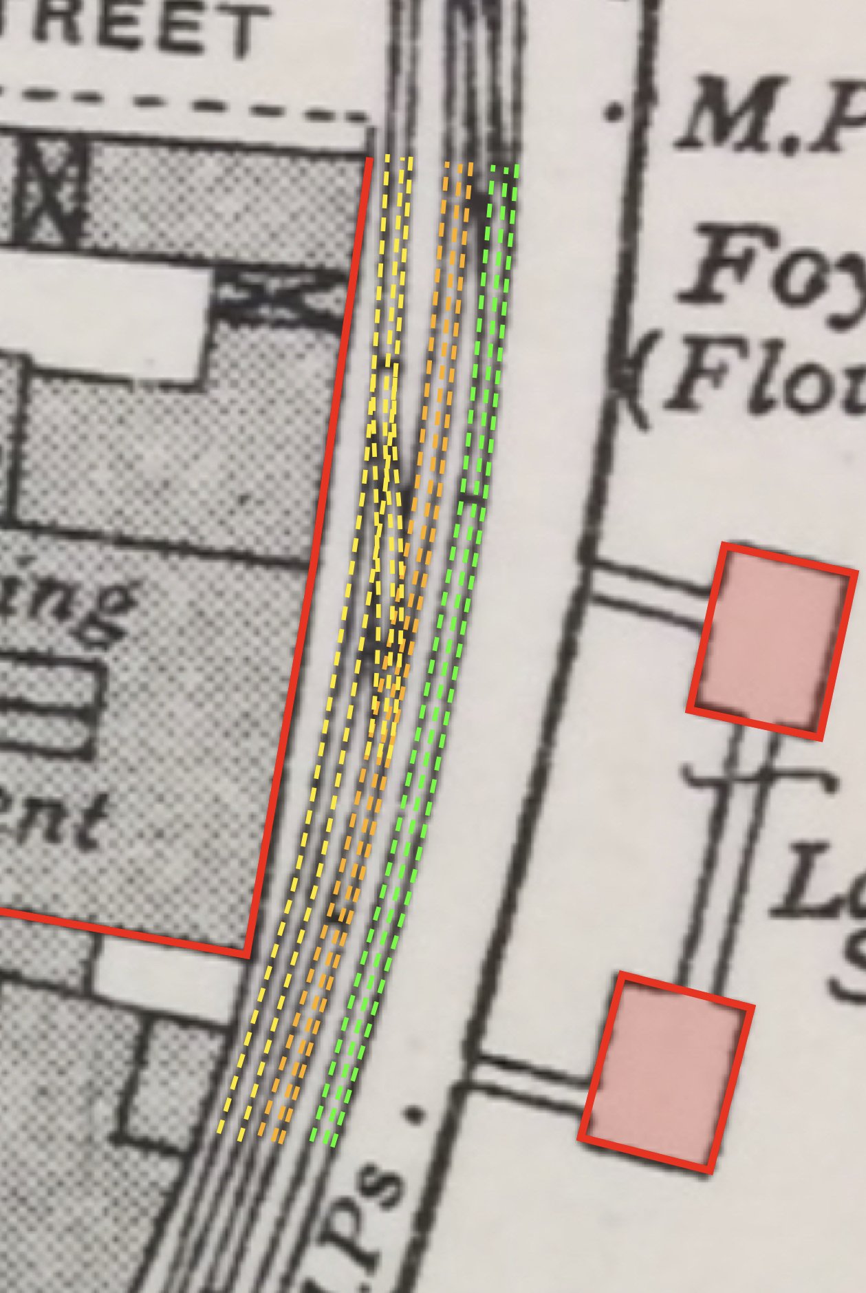
Thanks for the replies. Unfortunately, there’s nothing to say where that mixed gauge phot is actually located. Looking at the photo in question, the following observations:
- it’s facing north with the river bending to the left
- the dual gauge track always had the ‘common’ rail on the landward side
- the building on the left is on the landward side and some of it’s features seem to match where I have indicated with arrows
- it can’t be where the previous person indicated between warehouses and transit shed - not enough tracks and wrong direction
- there are very few locations where dual gauge track does not exist
My drawings show (early 1960s):
- 1 broad gauge track parallel with the dual gauge track leading up to the wagon turntable on the bridge
- continuation of this line beyond the bridge has a short section of 4 rail dual gauge track which stops at the fence boundary
- another track in the vicinity is narrow gauge (see photo looking back at Foyle Road station with the BCNR / LMS / NCC / UTA good depot in front of it). Note: I haven’t plotted that one yet, because I think it was gone by the 1960s.

Should have included key.
Don’t know. Need more photos……
-
Thanks Galteemore
-
 1
1
-
-
Sorry, what’s a PM?
-
Hadn’t thought about crossways sets and entrances. If the last photo is the location, then when did the broad gauge bit get added. It’s a mystery.
-
I tend to agree with you. Wonder if anyone has more photos of this area?
In hope………
-
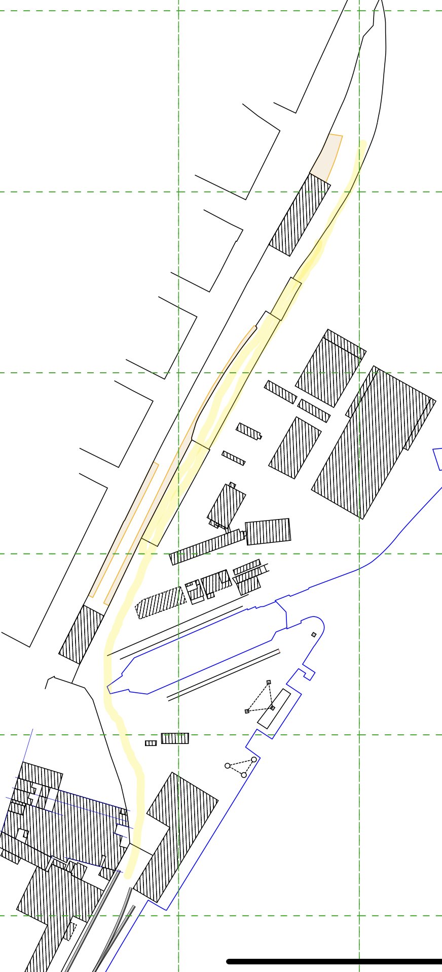
While I’m at it…..
Anyone have photos of the section roughly drawn in yellow?
Got plenty of Graving Dock Station and goods depot, but not what’s behind the platform wall.
-
Thanks for the replies. Unfortunately, there’s nothing to say where that mixed gauge phot is actually located. Looking at the photo in question, the following observations:
- it’s facing north with the river bending to the left
- the dual gauge track always had the ‘common’ rail on the landward side
- the building on the left is on the landward side and some of it’s features seem to match where I have indicated with arrows
- it can’t be where the previous person indicated between warehouses and transit shed - not enough tracks and wrong direction
- there are very few locations where dual gauge track does not exist
My drawings show (early 1960s):
- 1 broad gauge track parallel with the dual gauge track leading up to the wagon turntable on the bridge
- continuation of this line beyond the bridge has a short section of 4 rail dual gauge track which stops at the fence boundary
- another track in the vicinity is narrow gauge (see photo looking back at Foyle Road station with the BCNR / LMS / NCC / UTA good depot in front of it). Note: I haven’t plotted that one yet, because I think it was gone by the 1960s.
-
1 hour ago, airfixfan said:
Did an article on the LPHC in February 2021 issue of Railway Bylines with maps and some rare photos.
I Googled the magazine (never heard of it till now). That issue is missing from the list. Any chance you could provide me with a copy of the article?
-
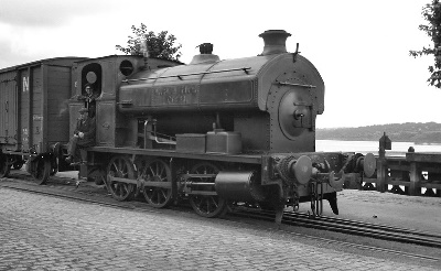
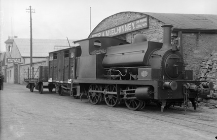
On 12/12/2015 at 2:47 PM, Dhu Varren said:
Below is a picture of Derry docks with an arrow showing where I believe the original picture was taken.
http://www.britainfromabove.org.uk/image/XAW027080
Here are also two pictures of the LPHC locos, No1 in what has to be a posed shot with both broad gauge and narrow gauge wagons behind it, at the entrance to the loco shed. Also No3 taken towards the L&LSR Graving Dock Station further along the quay. Note the offset NG coupling on the buffer beams. Note the rope wound round the buffers of No3, used for dragging wagons into parallel tracks.
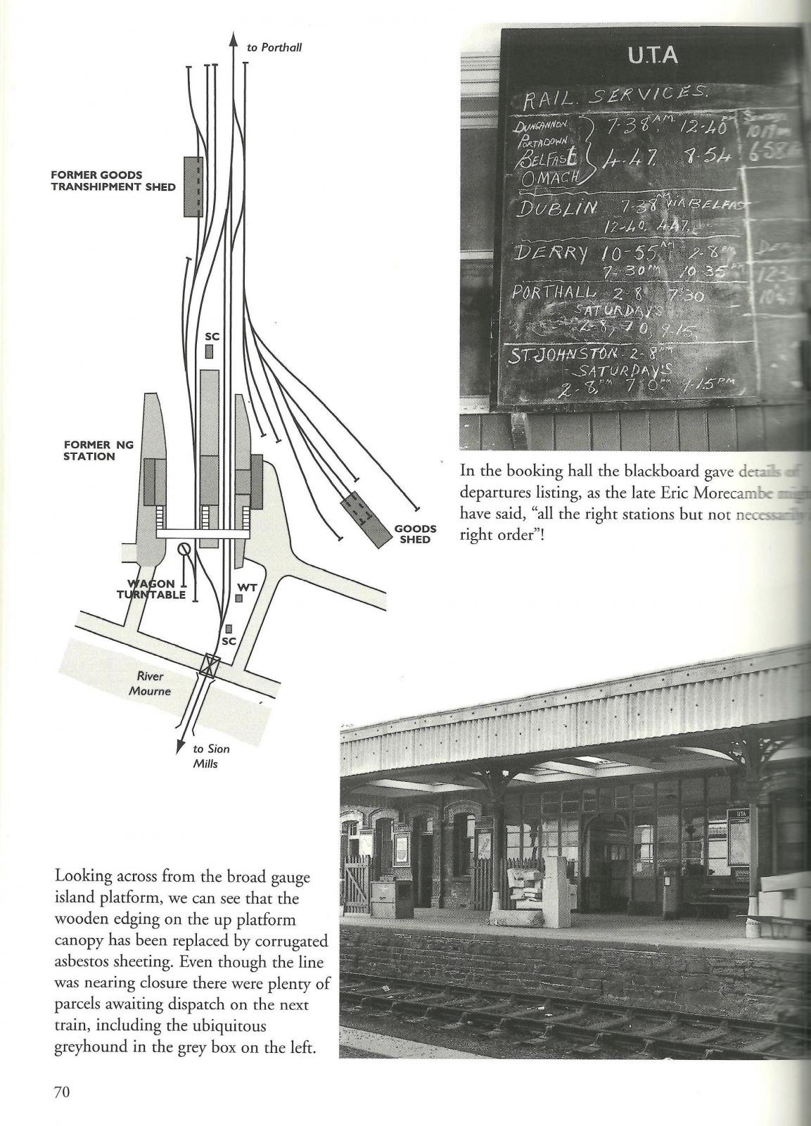
I’m working on evolution of track layouts for the CDRJC (and predecessors) and the whole of Derry / Londonderry. I too am having a great deal of trouble locating that mixed gauge photograph. Here’s my thinking on the subject, after studying lots of OS plans and photographs, particularly aerial ones.
-
1
-
-
Does anyone have a photo or photos that show the GNR(I) goods yard and its buildings? I’ve attached a close up of notes showing the goods yard. Also schematics I’ve been exploring of the large good shed (called a goods station on the Finn Valley Railway Act 1872 plans.
Can anyone please help? It might not even be a railway photo, but contain the buildings in the background.
The photo is an extract from a much bigger panoramic view taken from the old CDRJC bridge that crossed the GNR(I) line. It’s on the National Library of Ireland website. I had to enlarge the image on the site to get that small piece of the picture. It’s dated 1965. I think it’s after closure.
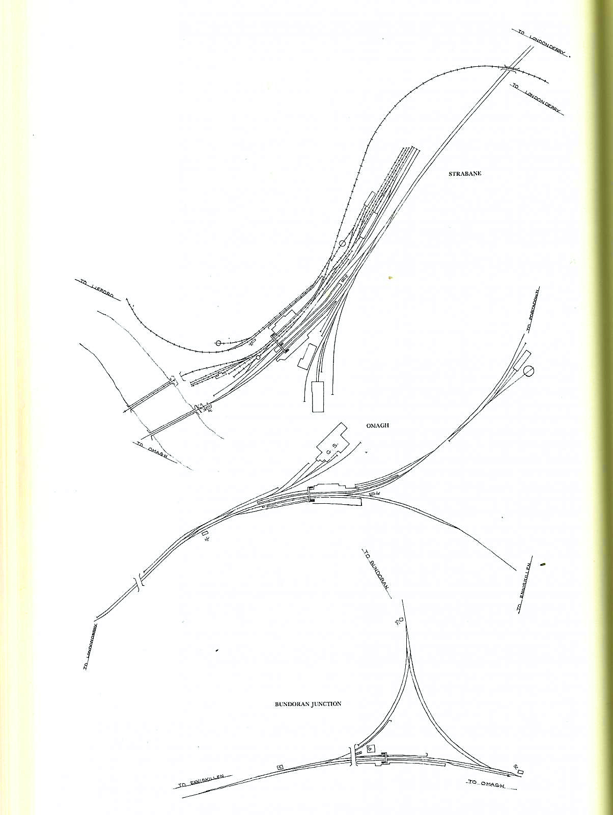
I’d really like to get photos of the yard and it’s buildings. Also, I can’t find any aerial photos of Strabane station and it’s surroundings. Does anyone know of any?
I have recently obtained really good 1:1056 scale (no I haven’t left a zero off that) 1883 OS town plan of the station. It has allowed more accurate dimensions to be measured for the good shed. See updated drawings.
The 3rd image shows the good shed arrangement shown on the 1872 Plan accompanying a Parliamentary Bill. Clearly, the shed was developed in stages over time. The photo of the building clearly shows what look like different stages of development. This seems to be confirmed by the 2 plans.
The extract from the 1864 Griffith’s Valuation map shows what might just be the higher structure seen in the photo.
-
Some useful photos on Sepiatown. http://sepiatown.com/813641/Post-Office-and-Emigration-Office
-
 1
1
-
-
11 hours ago, airfixfan said:
Thanks for your advice and I have over 40 photos and nearly 5000 words done already on just the history of the Strabane CDR station alone plus material to do GNR station soon.
We might be able to help each other? If interested send me a PM?
Hi,
The short answer is... yes, certainly.
Perhaps you could expand on your project so I get a better appreciation.
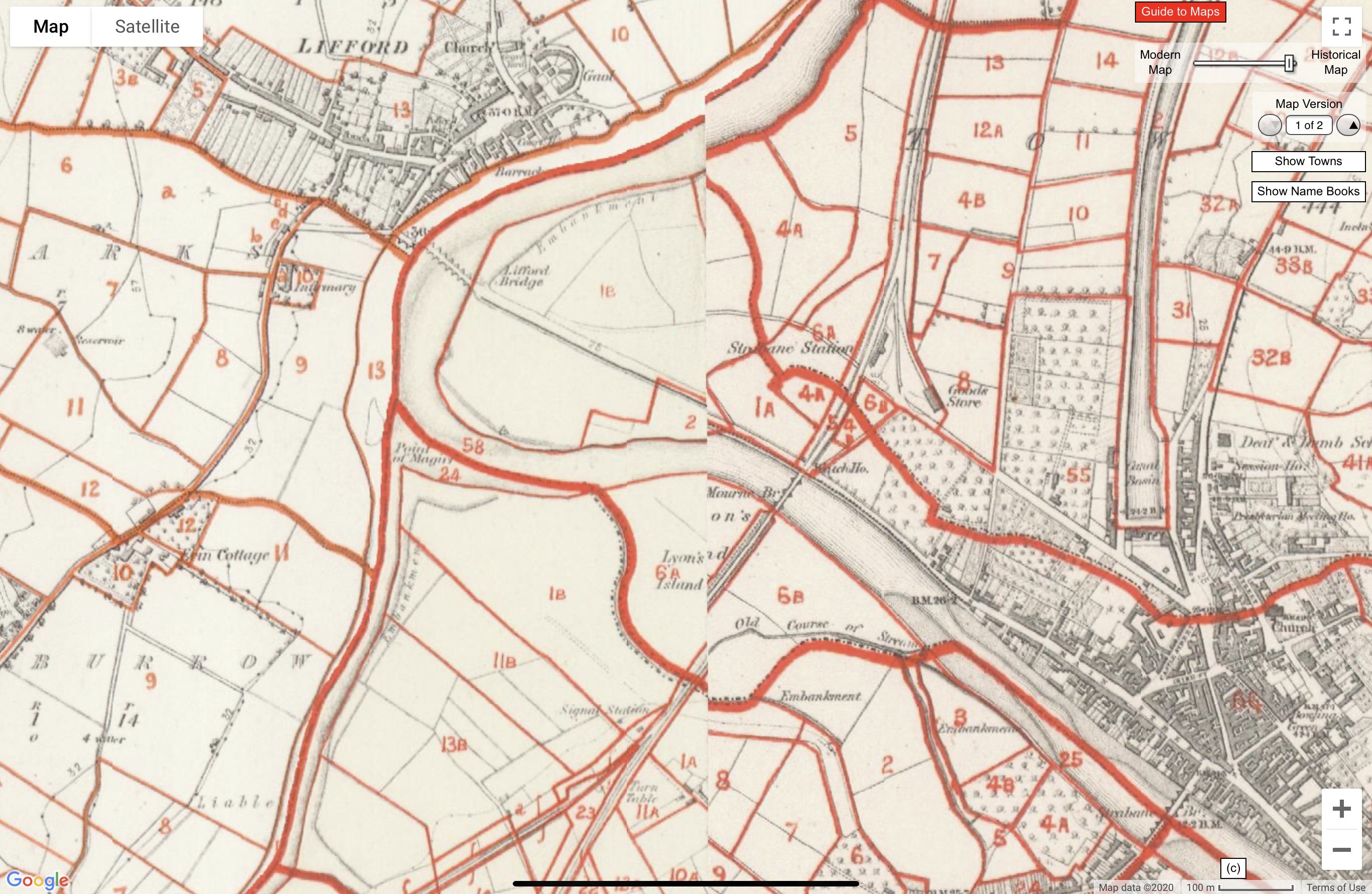
The c.1864 Griffith’s Valuation map shows the L&E and the junction with the FVR. Detail is limited by the nature of maps, but some larger isolated buildings are good reference points.
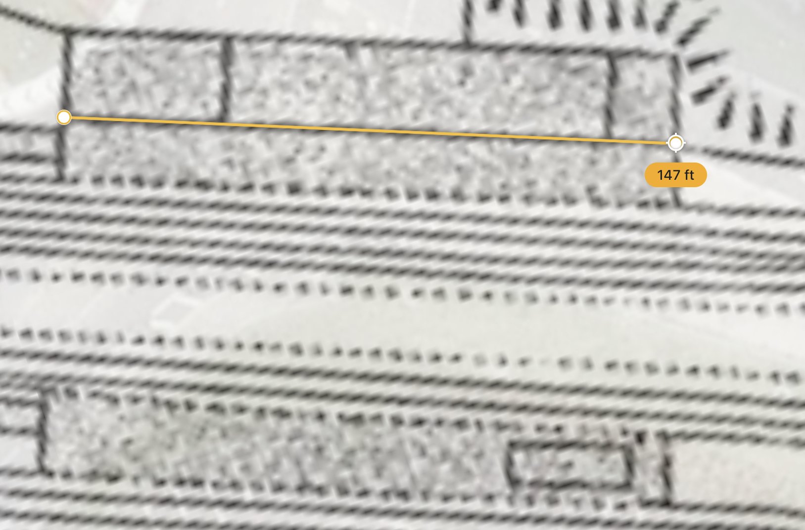
Using the 1:2500 on Google Earth it’s possible to obtain general measurements. See example attached.
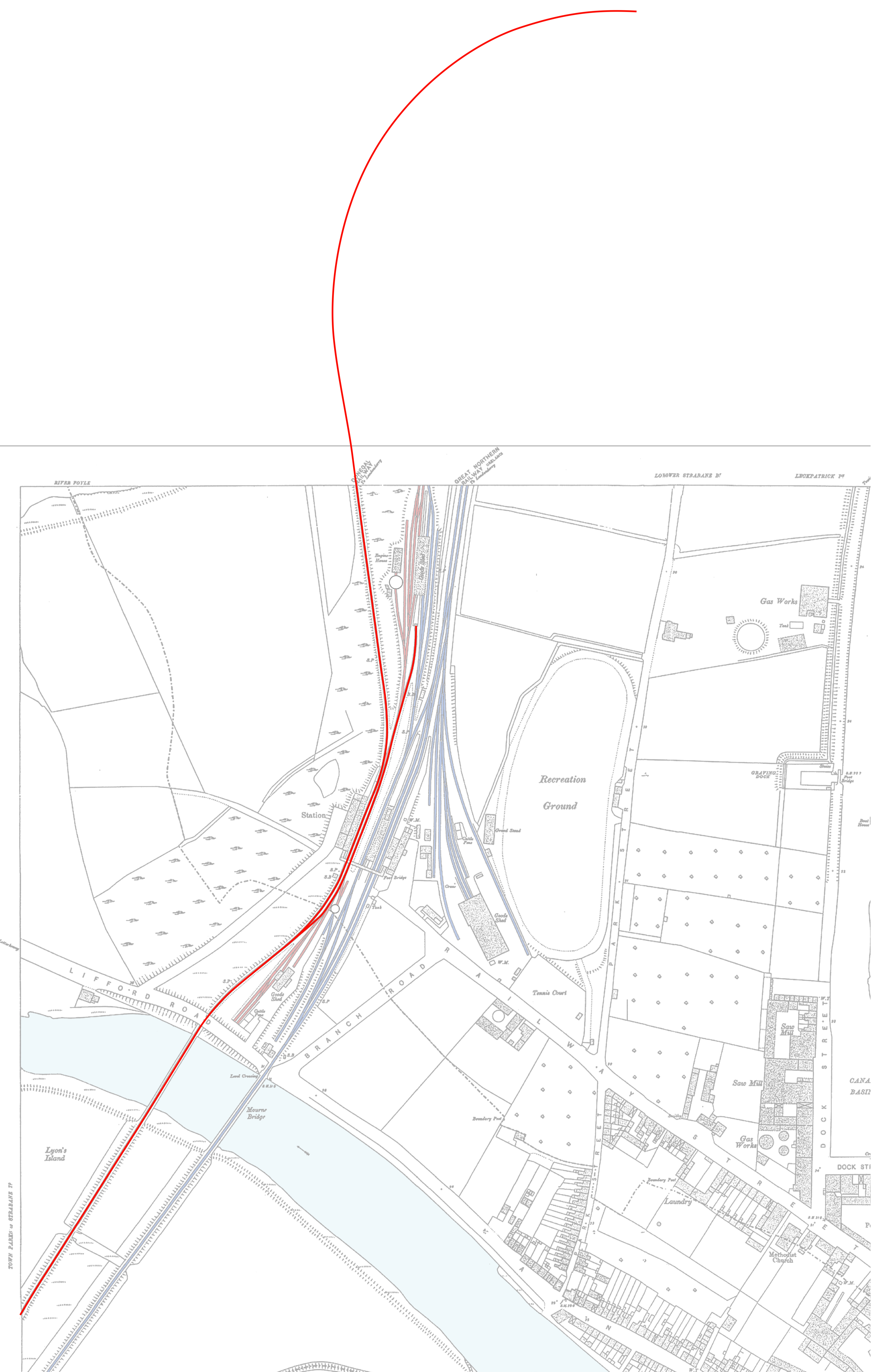
The next image is all I’ve done on Strabane to date.
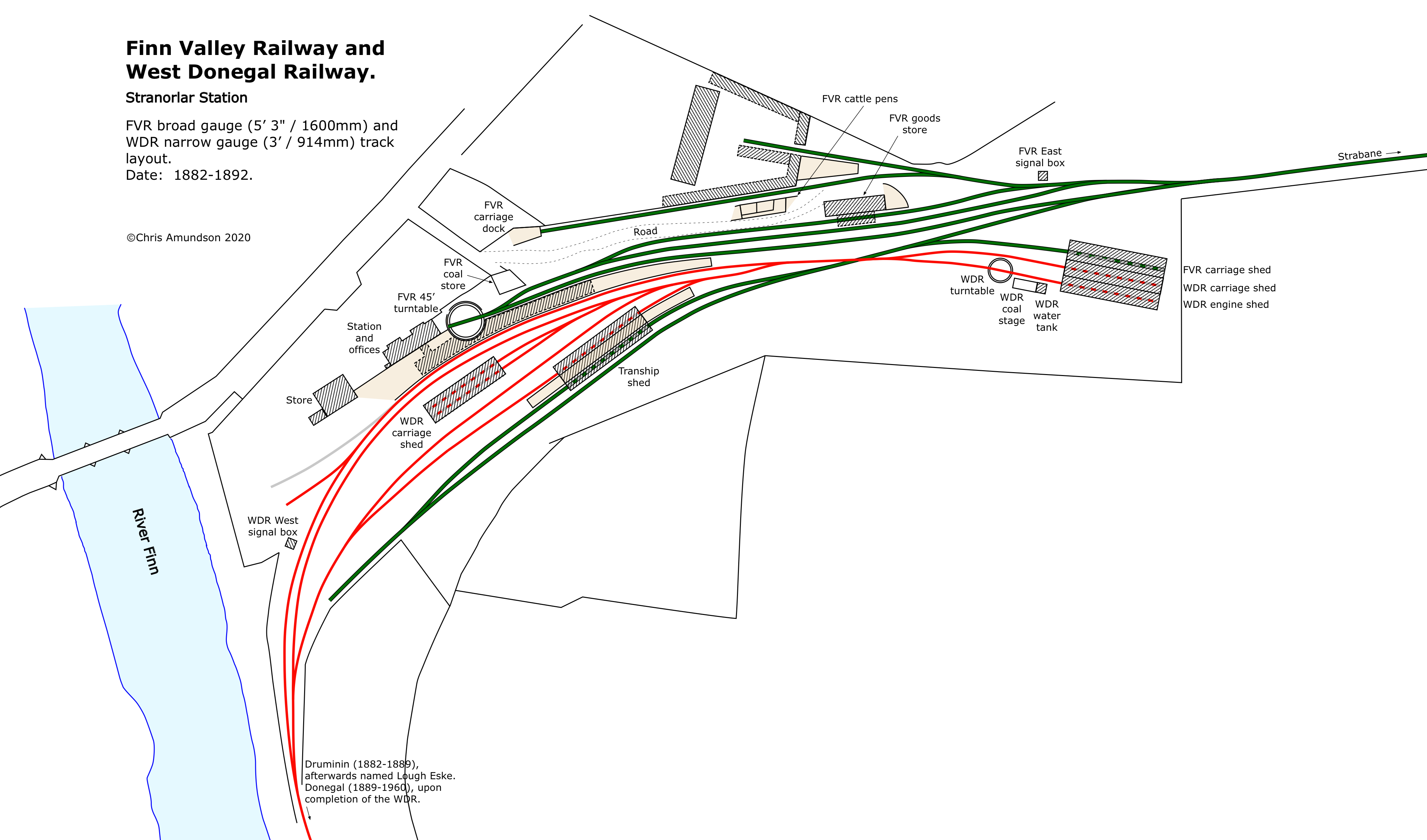
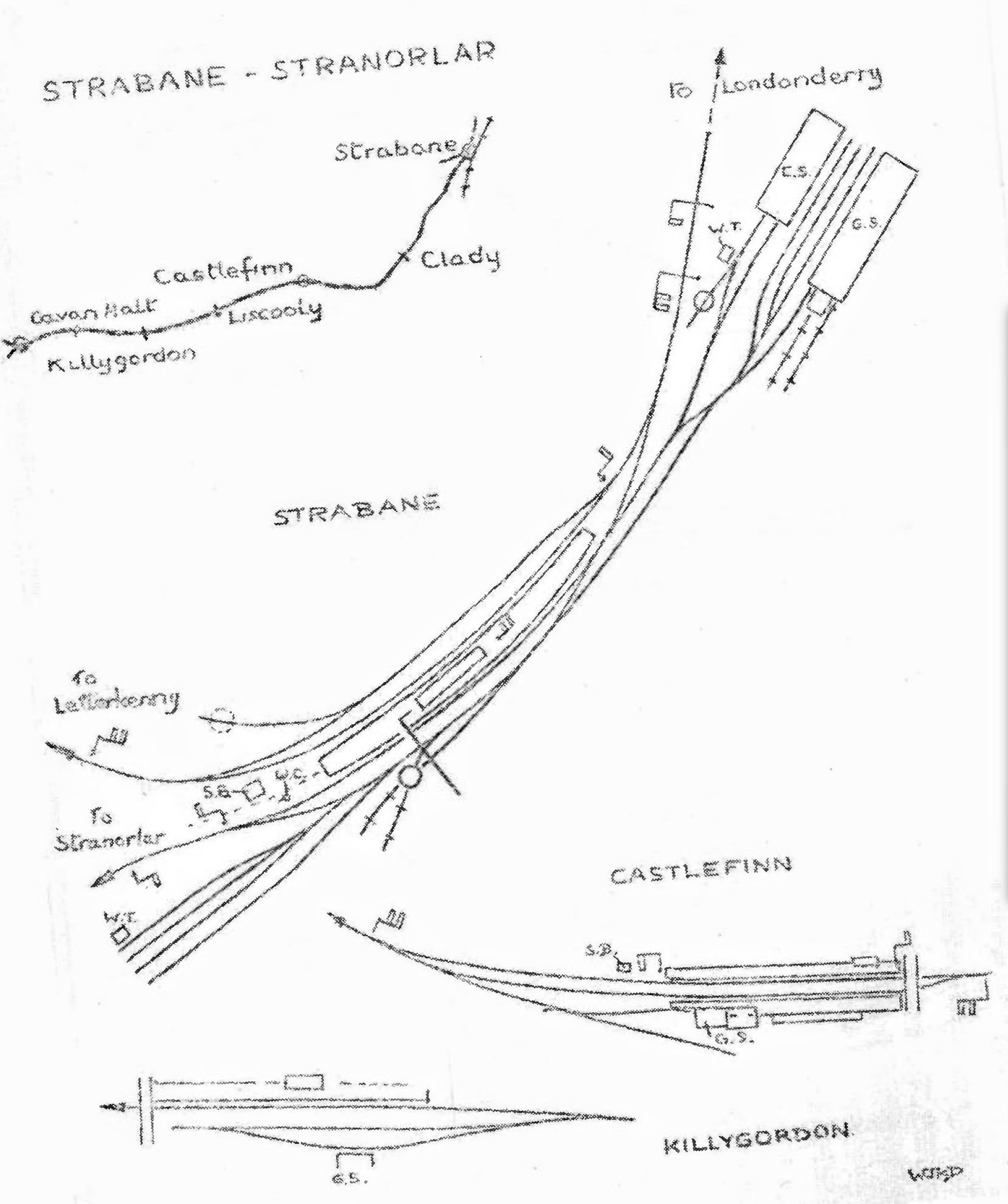
The final image is an example of what one of my finalised drawings - this time Stranorlar.
Any of this any use?
-
1
-
1
-
-
On 7/10/2020 at 10:42 AM, airfixfan said:
Doing some research on the station for an article. Have loads of photos and information on post WW2 period. However cannot find any photos or maps pre 1905. Even the online maps for both NI and ROI are blank for the area where the railway station is! Any suggestions or help?
Hello,
I am not a modeller, but have recently been researching CDR station layouts. I’m working on Stranorlar and getting information for Strabane.
I might be able to help with Strabane. I have spent my life working with maps and plans in the UK. Now I’m finding out about Irish coverage, or lack of.
OSi have the old 1:2500 (25") accessible online. As you have noticed, the S&L is later than the plan surveys. Some coverage exists with the 1:10560 (6") maps, but track layouts are very generalised.
PRONI - for some reason - do not have the 25" series online.
Fortunately, there is a blog that has some coverage:
http://oldstrabane.blogspot.com/2010/09/1905-ordnance-survey.html
It is possible to download the plan shown without the help of Google Earth.
The reason you are seeing blanks is because (I think) of the way PRONI presents the 6" coverage. In other words, the blanks are because no sheets were available for that series. You have to switch between the different layers. By using screenshots, I was able to combine the sheet with the FVR junction and later coverage post conversion to narrow gauge.
You should have Patterson’s books and the later revisions by Joe Begley & Steve Flanders.
A previous post on this website included some additional information. Unfortunately, I can’t remember the posting. I can’t find a way of posting images here....found it.
One of the sketches was done by WJK Davies author of many narrow gauge books. The sketch looks post-1955, after closure of the line to Londonderry.
Hope this is of some help.
-
1
-
1
-


Mixed gauge
in Photos & Videos of the Prototype
Posted
OK, I stand corrected. Sorry about that. Must be the heat and having so many photos.