Chris_w
-
Posts
62 -
Joined
-
Last visited
Content Type
Profiles
Forums
Events
Gallery
Blogs
Everything posted by Chris_w
-
Stranorlar County Donegal Railway Station and Yard
Chris_w replied to Colin R's question in Questions & Answers
That’s OK. Glad it was of some use. Thanks for the link. That was new to me -
Stranorlar County Donegal Railway Station and Yard
Chris_w replied to Colin R's question in Questions & Answers
I have been buying digital copies of Parliamentary plans attached to various Bills and Acts. HL_PO_PB_3_plan1846_L65.Londonderry Railway Contact the Parliamentary Archives with this reference if you want to obtain this plan and other documents. They are very helpful. I know I’m breaking copyright, but it’s only a small portion of this particular plan. Not sure whether this was part of one of the finished schemes. The point is it gives heights above a datum (doesn’t say what that was) and some other heights. Almost looks like ground level; again there just isn’t enough information on the plans. You would probably need to obtain supporting documents with written details. Still it might give you a starting point. Note the gradient of the proposal is shown. Try cross-referencing with OS spot heights on their plans. Hope this is of some help (?)
-
Stranorlar County Donegal Railway Station and Yard
Chris_w replied to Colin R's question in Questions & Answers
Corrections: c.1907 = photo is dated May 1921.
-
Stranorlar County Donegal Railway Station and Yard
Chris_w replied to Colin R's question in Questions & Answers
I bought 2 of the former and 1 of the latter in digital form. Hardly anything of relevance in the bus magazine. An unexpected side was mention of 2 ex-South Down coaches. I do remember seeing South Down buses when I was very young in Lancing / Brighton. The anonymous photo collection looks interesting. I’ll email you separately about that. -
Ernies Massive Irish 1930's to 2005 Photo Archive
Chris_w replied to Glenderg's topic in Photos & Videos of the Prototype
Has anyone got early photos of L&LSR Pennyburn before the mid 1920s - preferably WWI and earlier? -
Stranorlar County Donegal Railway Station and Yard
Chris_w replied to Colin R's question in Questions & Answers
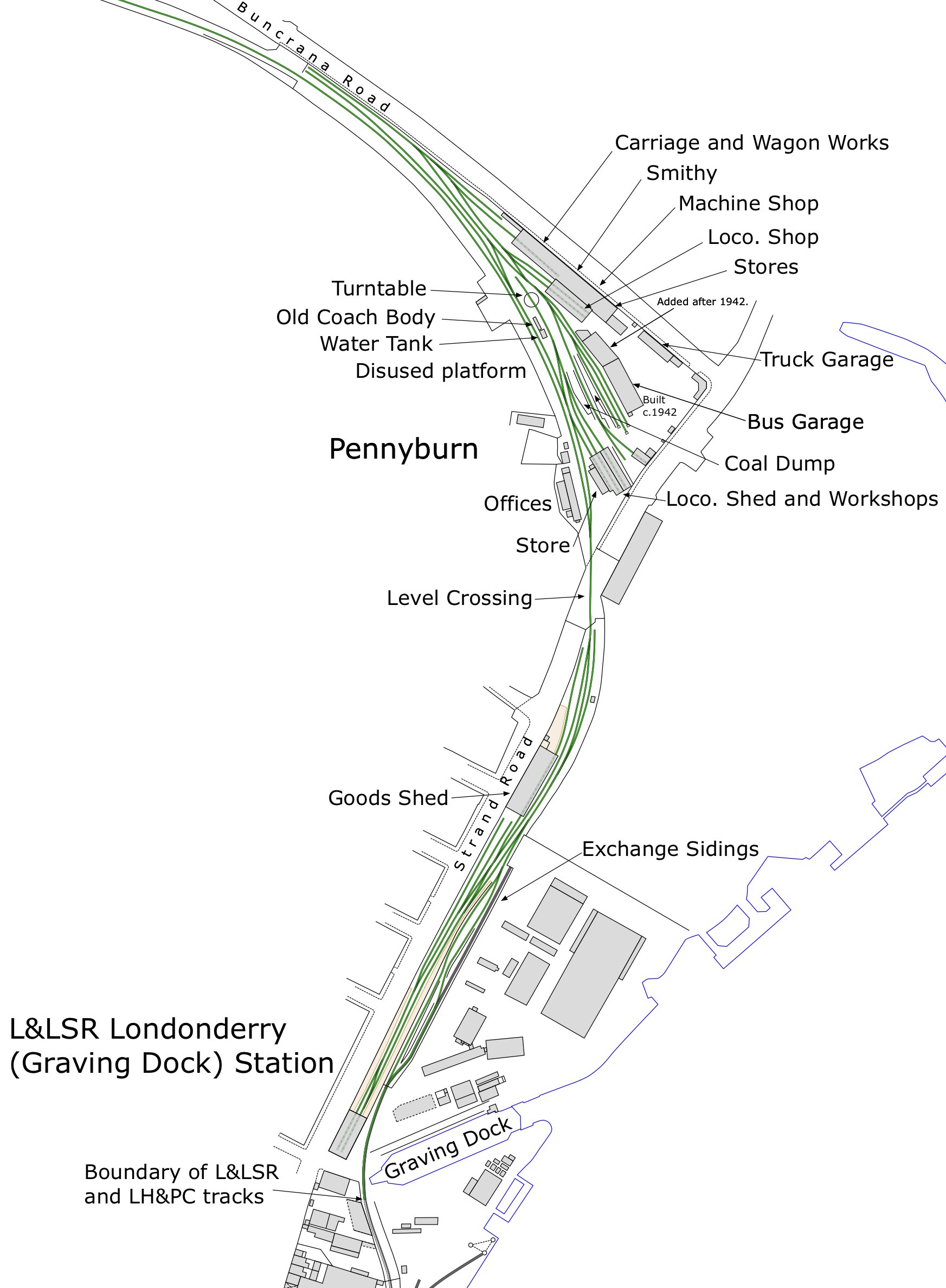
Can anyone help with questions on this attached infographic? I’ve only found one photo of the ‘mystery’ siding. Hard to date, but definitely before WWII. Also found no evidence of that coach body being located by the water tank earlier than 1948. Any help welcomed; especially photographs.
-
Stranorlar County Donegal Railway Station and Yard
Chris_w replied to Colin R's question in Questions & Answers
Thanks -
Stranorlar County Donegal Railway Station and Yard
Chris_w replied to Colin R's question in Questions & Answers
Can you let me know when it’s available? Is this one of your articles?? -
Stranorlar County Donegal Railway Station and Yard
Chris_w replied to Colin R's question in Questions & Answers
I have thought about Letterkenny; even got some extra OS plans, etc. BUT, still got a lot to do on Derry. Need that information from Derry Archives. -
Stranorlar County Donegal Railway Station and Yard
Chris_w replied to Colin R's question in Questions & Answers
You know the OSNI plans (1:1250 & 1:2500) have spot heights in metres. Earlier OS (1940s) we’re probably in feet. So, it’s possible to get a general idea of levels. -
Stranorlar County Donegal Railway Station and Yard
Chris_w replied to Colin R's question in Questions & Answers
Thank you . Hope you’ve seen my plans on Strabane and Derry-Londonderry on separate threads. Currently working on Derry-Londonderry. A Guide has been finished. Plans showing the whole of City (railway parts) are finished except the earliest. Now working on the individual stations, allowing for more detailed evolution. This is taking a long time, hence my publishing on this site. After that…. Return to original intention of producing plans showing the evolution of CDRJC (and constitutes). Next will either be Donegal or Letterkenny. Don’t hold your breath . -
Stranorlar County Donegal Railway Station and Yard
Chris_w replied to Colin R's question in Questions & Answers
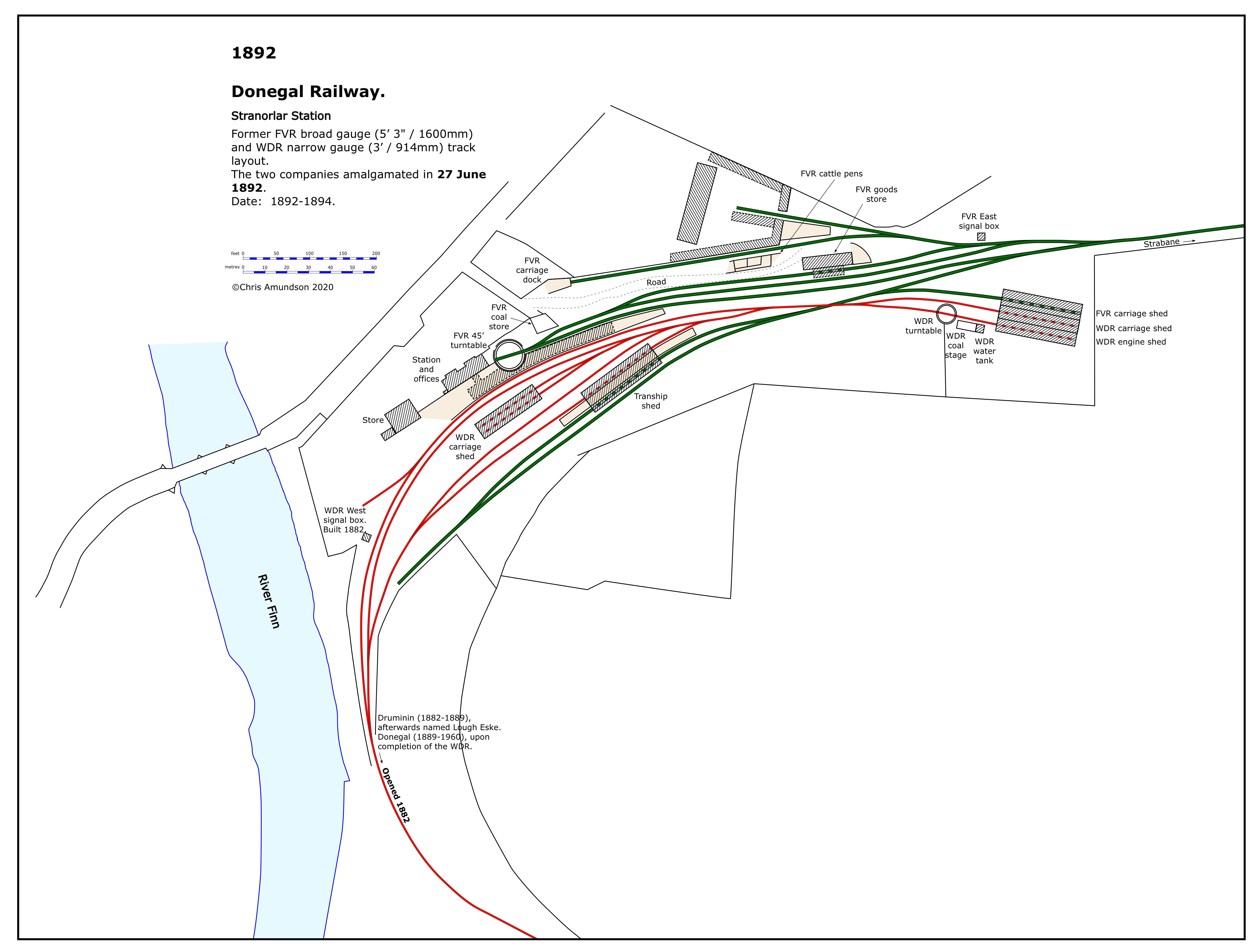
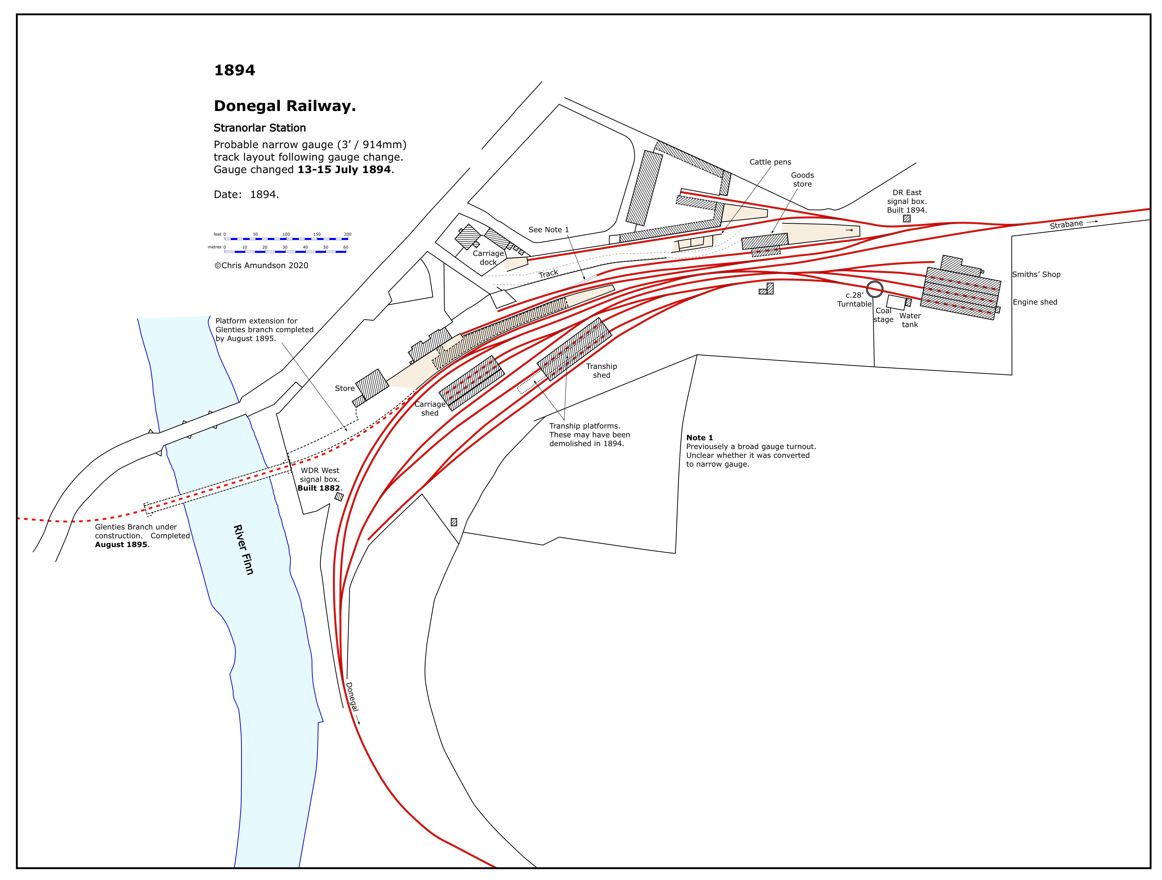
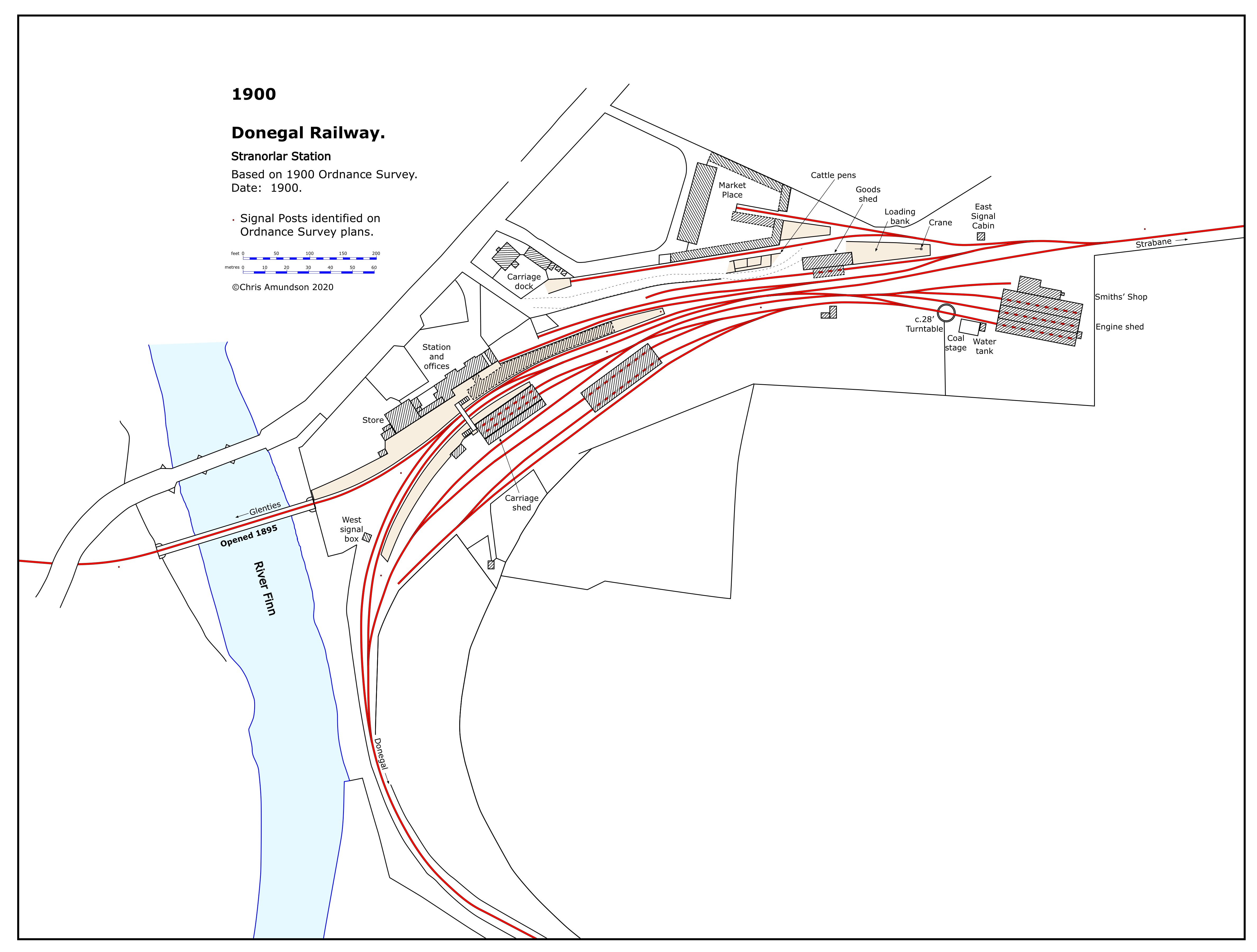
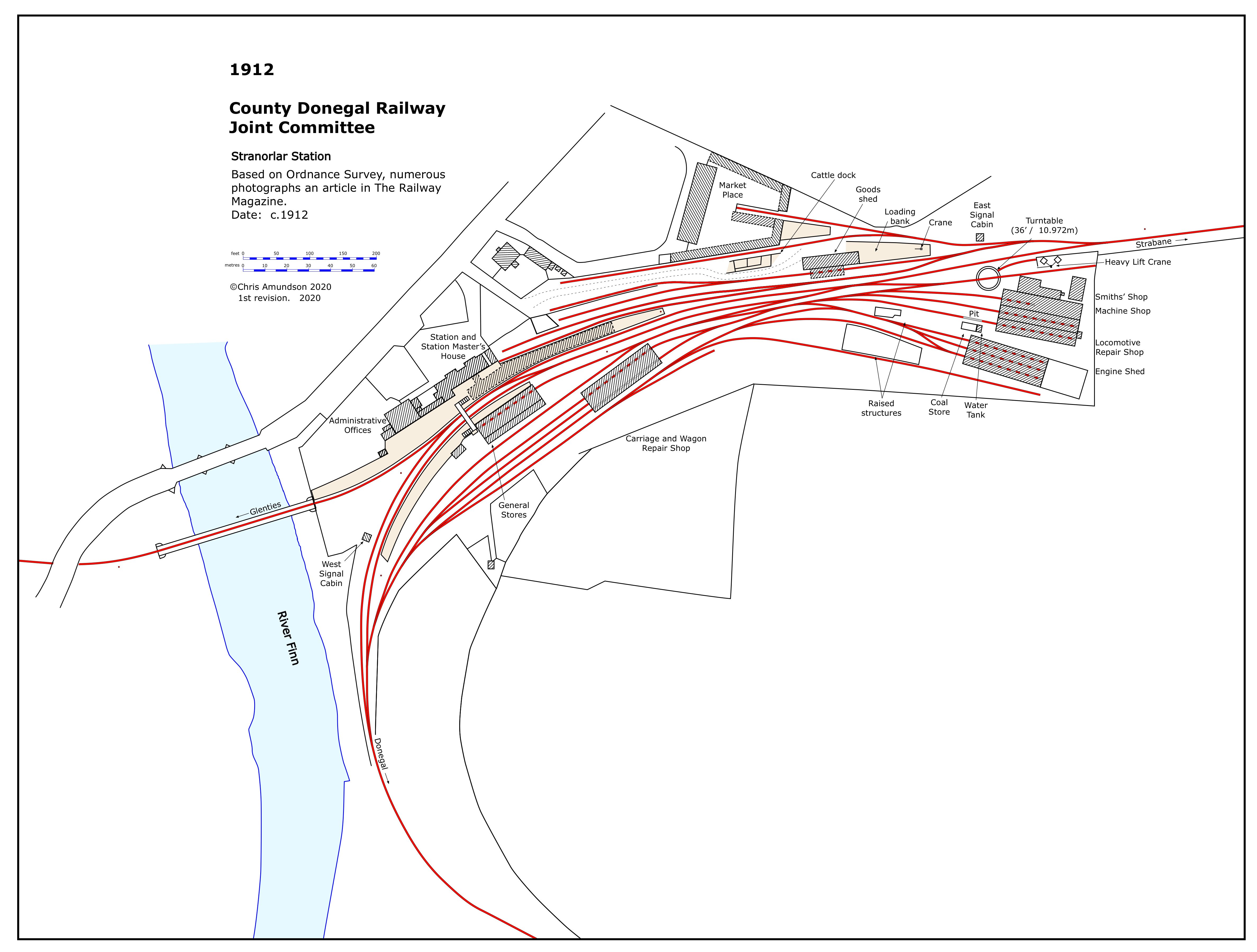
Following my publishing Strabane station evolution plans on that thread, I’m now doing the same for Stranorlar.
- 37 replies
-
- 12
-

-

-

-

-
Decided to upload complete set of Strabane
-
Ernies Massive Irish 1930's to 2005 Photo Archive
Chris_w replied to Glenderg's topic in Photos & Videos of the Prototype
Hi, Happy New Year. Do you know if any of the 500 have anything on Derry-Londonderry? -
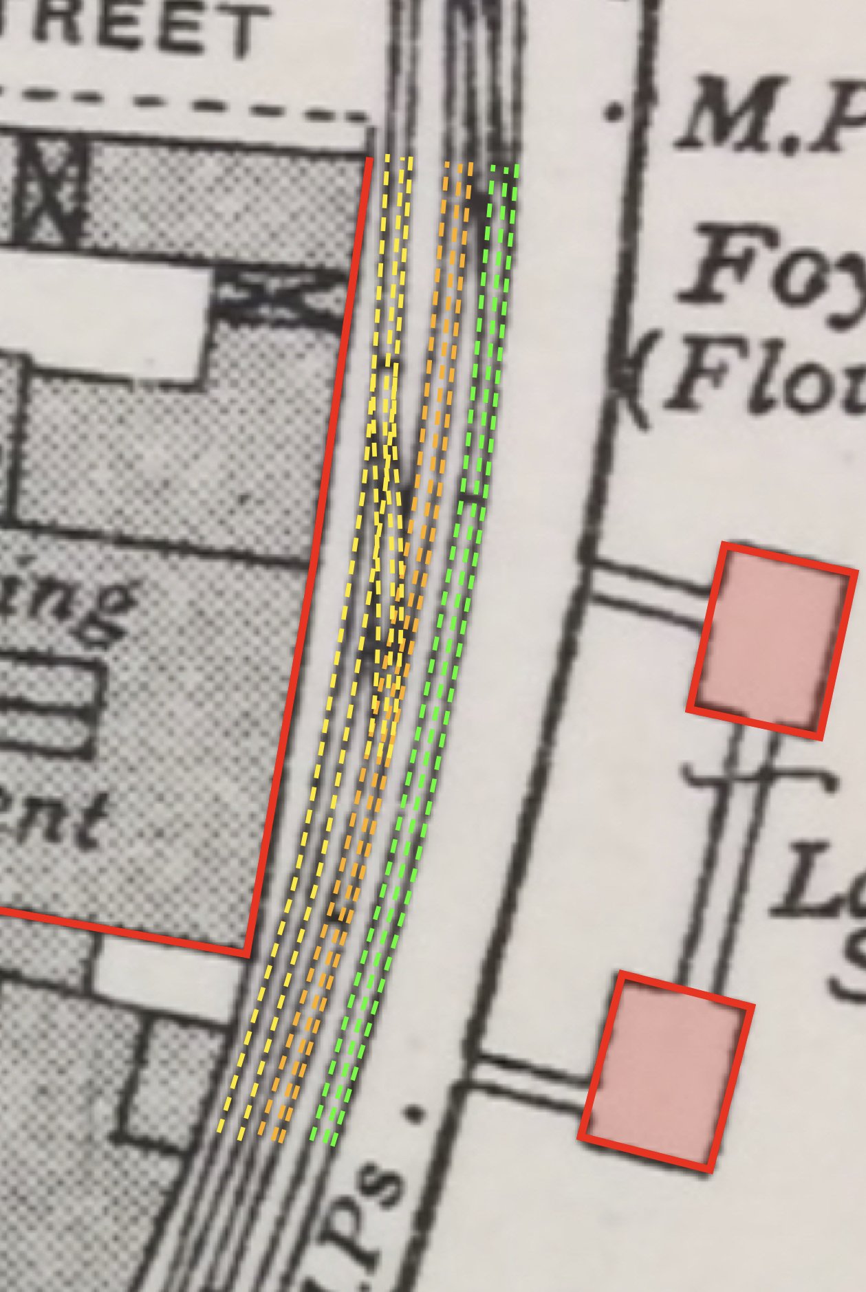
A request…. Can anyone help trying to find an original of the 1848 map / plan of Derry-Londonderry drawn by the Ordnance Survey for the Corporation? I believe the National Archive of Ireland may have one. There response for making a copy is difficult for me. If anyone is ever there, could they use a digital camera (smartphone) to photograph the small section of the plan? Although there is an online digital copy labelled 1848; it is in fact a revised version dating from c.1856. I’m attaching an infographic to illustrate these comments and identify the area required. It would be the only railway in Derry-Londonderry at the time. The ‘Gallows Strand’ terminus.
-
Scale…. That’s actually a difficult one. They are based OS plans 1:2500, but they are not reproduced to any particular scale. Each complete plan (map) does have a dimension scale so that you can measure. That’s the best I can do for you. This is the bottom half of the complete plan.
-
Strabane 1947 (CRA 2020) viewable on Flickr.
-
Reference "Victoria Road" station. Attached is an extract of a plan I’ve produced (CRA 2020) for 1948-49. Reference "Graving Dock" / Pennyburn. Another extract (CRA 2020) for 1953. Considering that the authors actually visited these places they didn’t get a lot of the details right, especially the L&LSR. Hope they’re useful.
-
Ernies Massive Irish 1930's to 2005 Photo Archive
Chris_w replied to Glenderg's topic in Photos & Videos of the Prototype
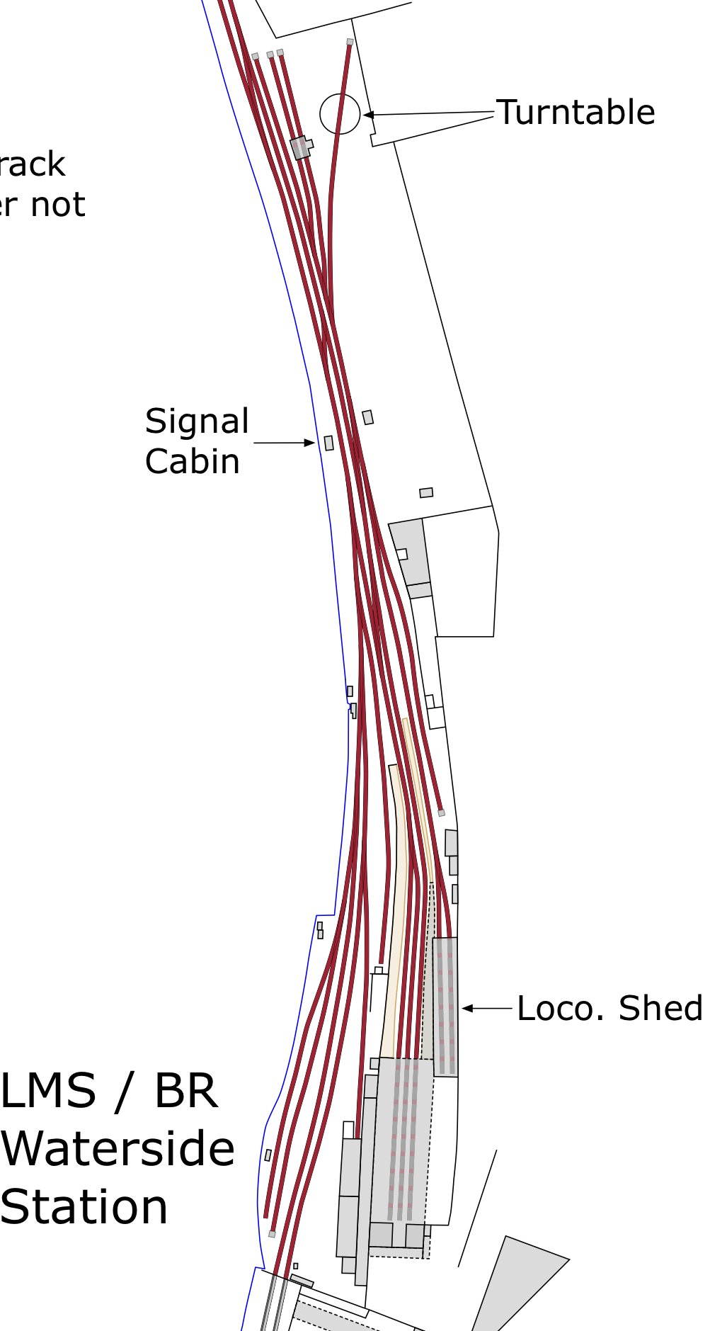
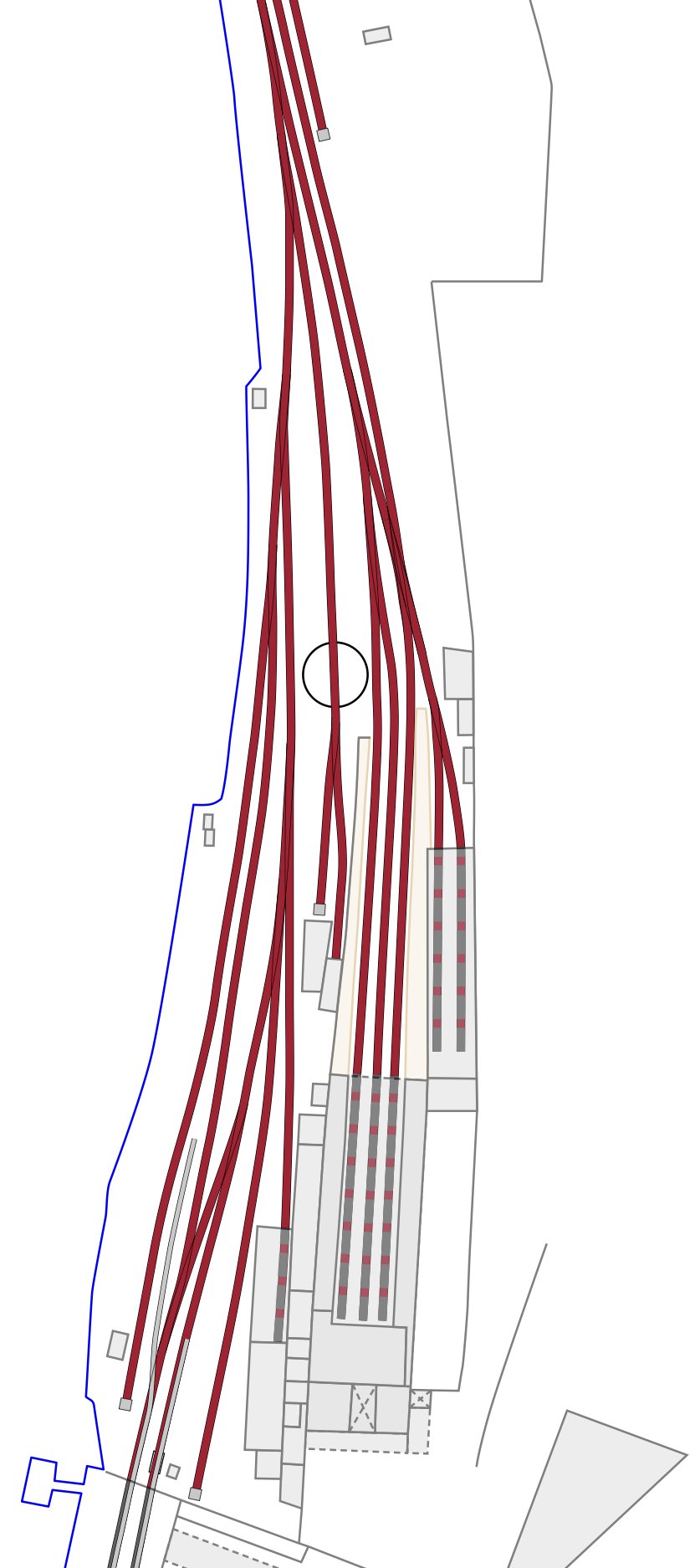
My painstakingly slow progress on Derry-Londonderry plans showing evolution of railways in the City have been finished (I hope) for early 1960s and late 1940s. Currently working on 1908. Attached are extracts from my work on Waterside, showing locations of the turntable at different times. The OS 1908 scale 1:1056 plans are the only ones that show dual-gauge track with 3 rails. Basically, it’s a revision of the 1873 1:500 scale plans; reduced to 1:1056. Sadly it doesn’t cover Pennyburn, but that’s another story. Hope these help.
-
OK, I stand corrected. Sorry about that. Must be the heat and having so many photos.
-
Thanks. However, it’s not another Britain from the Air photo. There aren’t a huge number of those and most are limited to NI. The best source of other aerial photos is found on the website of the National Library of Ireland. I think I’ve only found ~4 aerial photos from BfA. Most of the rest are NLI. There are also some newspaper ones (based in Belfast) - can’t remember the name off hand.
-
LOCATION SOLVED………
-
Hi, would you be willing to share them online or privately?
-
Maybe…. Done some drawing / photo comparisons…. What do you think? Close up of track drawing….
-
Should have included key. Don’t know. Need more photos……