
Colin R
-
Posts
1,124 -
Joined
-
Last visited
1 Follower
Colin R's Achievements
")


-
 I am not sure just how far Neville has got with getting this kit back into production, but I wouldn't mind finding a second one for sale. I know that there is a 3D print version available, but for now I would prefer a brass etech version.
 -
The same principle could be used on a WCR/CDR/IOM Railcar model, which again could increase sales volumes. Speaking of which, has anyone measured up the Worsley Work Donegal Railcar? As I am convinced that he uses the WCR drawing and not the Donegal drawing, since there is a difference between the two of them.
-
Well, a bang on the door from a new postie, and they had arrived: my four Green Park Royals . Well, I will wait to see what you guys make of them, but they look like the DBs to me. Well done to Fran and the Boys. Now about that proposed layout
-
I would agree about market share, but what is stopping them from being made for both 009 and HOm, like the Bemo ( V51/52) https://www.bemo-modellbahn.de/produkt/db-v51-902-diesellokomotive/ Bo-bo locos, which had the wheel sets pushed out to 12mm gauge, or you could move them in for 009, just a thought
-
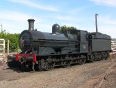
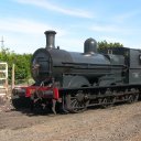
Well, someone has to put it up, but how about the West Clare bogie diesels or the railcars, both for 12mm gauge, not sure how many would sell, but I bet some would get them just to try them out.
-
I would be interested in two kits Colin
-
I have just been pointed in this direction for Lynton and Barnstaple Transfers for 16mm scale, so it might be worth dropping them an email to ask about Donegal transfers https://www.endonvalley.com/
-
try these http://www.drytransfershop.co.uk/index.html
-
Hi, Thanks for that, it is these little things that make the difference between Irish and UK model railways.
-
Hopefully, I have been able to change part of my order, but looking on the web, it states that only 40 of these coaches were made. I am ok with that, but were any built with a brake van section? If not, what would be suitable to run with them? I am looking at my copy of the GSWR Carriage Diagram Book (which someone kindly let me have) for something which I could build (my only comment about the above book is make sure you measure the drawing, as I think in the printing process the dimensions have changed). I happen to like coach No 875, a 1st /3rd Brake. The only problem I have is that I only have a drawing for one side of the coach, and that is the one with all the doors.
-
Hi Guys I have just missed a programme about Irish Railways in the 1940s and 50s today, Sunday 19th April 2026. Tomorrow, Monday 20th, at 1 pm, there is another programme in the series about the Donegal and Swilly Railways. In the UK, it is channel 71, That's TV 3 Now. I am not sure if you can get this in Ireland, but you might get it in Northern Ireland and the rest of the UK. I can't see a streaming service yet, but it appears they may be showing more Irish Steam/Railways on this channel over the coming days. Regards Colin Rainsbury
-
Ok, thanks for that. Hum, I might have ot see if I can swap it out for another green one before they land in that case. I do hope that a second batch with different numbers will be done at some point in the future The proposed layout is to be based on Downpatrick, back in the 1950s, before it was closed. At some point, when the modelling budget allows, I would like to buy one or two railcars from that period
-
I have ordered a buffet Car in Orange and Black since I am not sure if they ran in the green livery, as the rest of the order is all green livery. I was just wondering, can someone who has a lot more knowledge than I do, can you please:- 1 How many carriages would be used to make up a typical suburban train set? 2 How many carriages would be used on a typical City to City Express set?
-
I can't help but think you would be better off just producing an unpainted version like Dapol and selling them by the boxful

