Darrman
-
Posts
161 -
Joined
-
Last visited
Content Type
Profiles
Forums
Events
Gallery
Blogs
Everything posted by Darrman
-

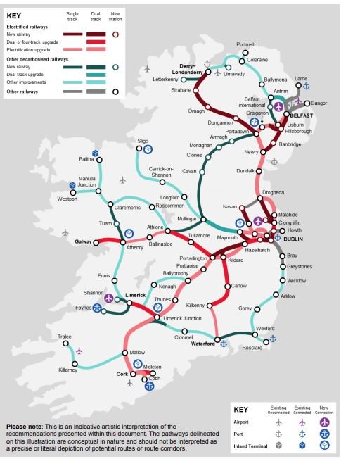
Single lines, block sections, travel times, and train frequencies
Darrman replied to Darrman's topic in General Chat
Johnson's Atlas and Gazetter is the best source for broader data such as station locations, with the caveat that is was published in 1997 so some newer developments aren't represented in it. OpenStreetMap is also a good place if you need to take a closer look at a particular location. The route a modern Sligo intercity train takes is composed of several sections built to access the North Wall before reaching the former Midland Great Western Railway's main line at the site of Liffey Junction, near Broombridge. It follows this as far as Mullingar (the main line used to reach Galway, but the section between Mullingar and Athlone is disused) before it branches off towards Sligo: I've everything relevant listed below. It's worth noting the distances are measured in miles and chains as this is what they were measured in when originally built: there are eighty chains to a mile. Mileages sourced from Johnson, the line speeds from Irish Rail's network statement. Mileage from Islandbridge Junction (at the western edge of Heuston yard) Line speed: 30 mph Dublin Connolly (Platforms 5-7, Amiens Street Junction): 4:61 Drumcondra: 3:28 Glasnevin Junction: 2:53 (mileage change: MGWR North Wall branch, from Liffey Junction) Glasnevin Junction: 0:57 Liffey Junction: 0:00 Overall, the section between Connolly and Liffey Junction is 2 miles, 65 chains long. Mileage change: Midland Great Western Railway, from Broadstone (the original MGWR terminus, now closed) Line speed: 70 mph Liffey Junction: 1:33 Broombridge: 1:67 Pelletstown: ~2:30 (approximation) Ashtown: 3:08 Castleknock: 4:68 Coolmine: 5:56 Clonsilla: 7:08 Leixlip Confey: 10:20 Leixlip Louisa Bridge: 11:20 Maynooth: 14:72 Double track ends here. Line speed: 75mph Kilcock: 18:50 (no passing loop) Enfield: 26:40 (no operational platform at loop, passenger trains cannot stop when using it) Killucan: 41:58 (station closed, passing loop still in use) Mullingar: 50:17 (passing loop) Edgeworthstown: 67:52 (passing loop) Longford: 76:22 (passing loop) Dromod: 87:25 (passing loop) Carrick-on-Shannon: 97:62 (passing loop is located just north of the platform) Boyle: 106:33 (passing loop) Ballymote: 120:15 (no passing loop, second platform still evident) Collooney: 127:56 (no passing loop) Sligo MacDiarmada: 134:16 (two platforms, but only one currently in use; two tracks for a few hundred metres approaching it) Today's Sligo intercity trains travel 135 miles and 48 chains in total. Many stations have been closed along the line: I've omitted them when not of operational relevance. I've similar information for the rest of the country, but it would take a while to properly clean up and make presentable. -
https://www.echolive.ie/corknews/arid-41559028.html Platform 6 completion scheduled for March, signal upgrades and doubling to Midleton on target for 2026 completion.
-
The Strategic Rail Review has the most hypothetical electrification, and that doesn't get any further than Athlone, and that's well short of Ballina. The Navan branch is just greyed out here, but if Taras ever restart that hypothetical could just use the direct route. Of course, the electrification this mentions focuses on the major passenger routes, not freight. Of course, we all know how long it takes to build anything in this country. Beyond Dublin, electrification doesn't exist, and Dart+ isn't exactly moving at a breakneck pace. (Hopefully they figure out a new depot sooner or later.) As for the 071 modifications, they're getting on in years. If converting them to hydrogen power lets them work better and for longer, then great. If not, then we'll know for the future.

-
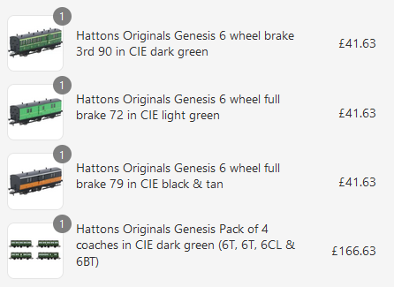
I just went ahead and bought a bunch of coaches. I probably bought too many brakes, but I imagined a train in West Cork having a 90 at both ends of the train - a good enough reason for me to hit buy. Besides, my birthday's coming up, it's train purchase season.
-
https://www.corkindependent.com/2025/01/08/rail-returning-to-west-cork/ I got sent this article: interesting, I must say... The plan is for 500 metres of narrow gauge (15 inch, more specifically) to be laid. The fundraiser does mention wanting passenger rides, insurance allowing - if it comes about, you'll know where to find me! No relation to the Bandon!
-
https://www.echolive.ie/corknews/arid-41547553.html The Echo reports that the government have applied for another round of funding from the European fund covering these works. The headline says "electrification", but the article says "enable future electrification". The money is conditional on unspecified milestones being met, but with construction going apace I think there's no danger of that.
-
Setting the politics aside, does anyone have any pictures of these sidings being removed? Is there any chance of it being just some form of maintenance? And are there any planning applications for the relevant land? Concerning, certainly, but we don't have any great amount of information aside from "the sidings are gone".
-
https://www.irishtimes.com/transport/2024/12/04/proposed-navan-dublin-rail-line-likely-to-cost-up-to-3bn-transport-authority-estimates/ Article in the Times prices Navan at €2-3 billion, up from €1.5-2 billion in 2021. Inflation is blamed for the revised estimate. For comparison, I tried to find the cost to build up to M3 Parkway and I found this: (source: https://www.railway-technology.com/projects/dublinnavanrailline/) "Phase I of the project is estimated to cost around €160m, while phase II will total around €500m. Phase I of the project is expected to be completed by September 2010 and phase II by 2015." Let's assume those estimates are accurate for 2010. A six-fold cost increase in fifteen years is not good. We better get a double-track electrified railway travelling at least 100mph for that...
-
mgwr preserved railway Connemara Railway project.
Darrman replied to ttc0169's topic in What's happening on the network?
I watched the section live on TV tonight. Whenever Maam Cross opens for business, I'll be there. Good luck! -
https://www.irishrail.ie/en-ie/news/project-development-for-navan-rail-line-to-begin Irish Rail press release today: RPS appointed as consultants, two years spent planning with a public consultation at some point in that, railway order application for 2027. Stations at Dunshaughlin and Kilmessan explicitly mentioned. Just speaking for myself, what's stopping them from reusing the pre-crash plans as opposed to going through planning again?
-
Single lines, block sections, travel times, and train frequencies
Darrman replied to Darrman's topic in General Chat
I've updated the frequencies for the 2024 timetables. Rather than flood the forum with a big paste I'll attach the relevant file. The most notable change is Grand Central's opening: 73 trains either way approach it from the Great Northern and 93 trains depart and 100 arrive from the Blythefield Curve and Belfast Central: I've no idea where the discrepancy comes from. Two extra Galways and an extra Waterford increase the numbers on the relevant lines (there's 19 trains from Athenry to Galway now), and with work to double Midleton underway that will remove a busy single-track section. Incidentally, the busiest tracks are all around Connolly: 143 trains depart towards Clontarf Road and 73/74 (there's a Mullingar service with no return) towards Drumcondra, while heading south 155 cross Loopline Bridge towards Pearse. Loopline Bridge certainly won't ever be quadrupled! There's still 105 trains travelling down the DSER to Bray: it badly needs something somewhere - no, dumping everyone out of the train at Wicklow and changing to a slow stopper is not a solution. Incidentally, the actual quadruple section, Cherry Orchard to Hazelhatch, has 97 trains a day, slightly quieter. But still necessary, plus there's the occasional goods train bound for North Wall. frequency2024.txt -
Since this thread's come back around, if I was to toss out any rationality I'd reopen Clonakilty, being the biased West Cork man that I am. Which by extension would force Bandon open again... And Albert Quay... Who needs the South Link Road and the skyscrapers on top of Albert Quay anyway? Black Ash park and ride could connect to the railway instead. And it's not that far from the Bandon Road either, you could put a park and ride there too. And then may as well reopen Waterfall. (Madness with crayons excised for everyone's sake...) Even if the West Cork never closed, I'd say there's a fair bet the first station out of Albert Quay today would be Bandon! (As of the June 1958 working timetable, the only stations not designated as halts were Albert Quay, Bandon, Ballineen, Dunmanway, Drimoleague, and Bantry, along with Skibbereen, Ballinascarthy, and Clonakilty on their branches. Clonakilty Junction is inconsistent: there's no H on the Clonakilty branch timetable, but there is on the main line.) I could try to rationally figure out how to work out how to reopen/how to prune West Cork so as to avoid total closure, but that's for another thread.
-
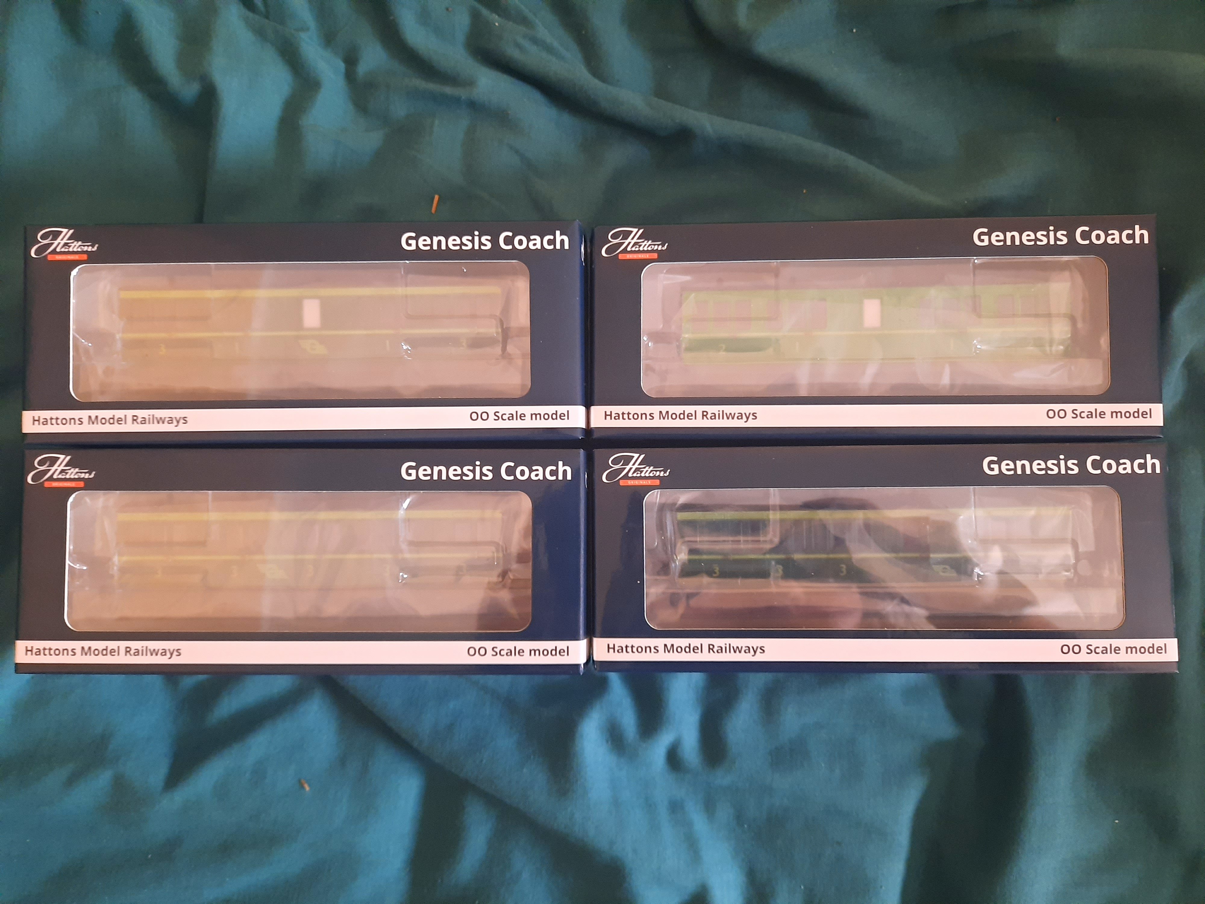
Finally, they're here. There was a hiccup during the customs payment but thankfully things resolved themselves and now these coaches are mine. Now I just need to pick up something that could run them!
-
Let it never be said that I am free of bias...
-
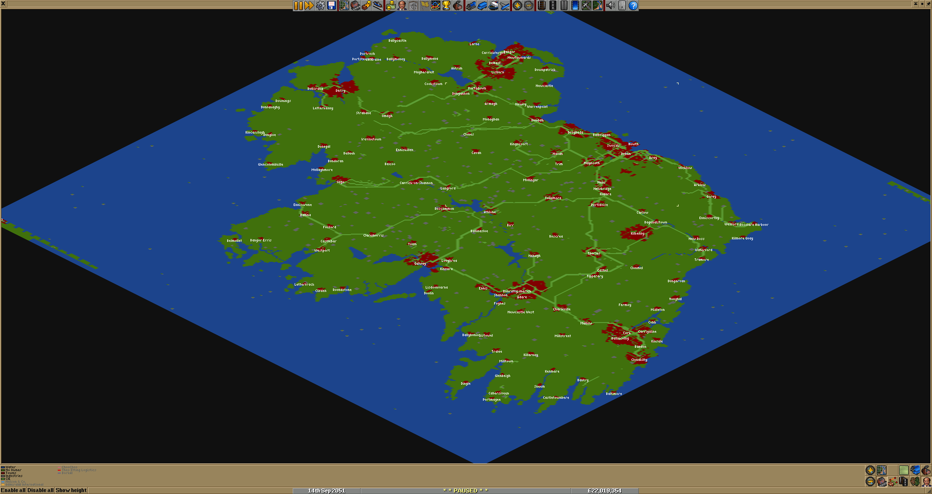
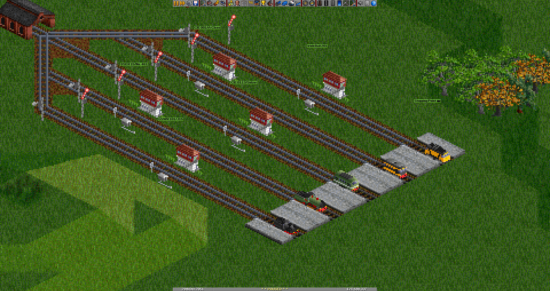
OpenTTD (Transport Tycoon Deluxe) has an amount of Irish content available. This includes a few different maps of Ireland (it can sometimes be found on maps of Britain too) and a small few trains. The aim of the game is to make as much money as possible, but you can also cheat yourself infinite money and focus on appearance: I'm currently building the entire historical network. After that I might experiment with a hypothetical modern-day network with less severe closures. Pictured is Ireland in 2050 at the end of my last proper Ireland game. The urban sprawl (red) can get a bit out of hand with enough buses spinning around in circles. My lines are the lighter green: I turned off the AI's various efforts. And here are the available Irish locomotives. 101s and 461 for steam, the Sulzer, As, and 201s for diesel. The game lets you choose between 16 colours for the main body and secondary details: the fixed black suggests Supertrain A and original 201 liveries. For whatever reason giving 461 a red buffer also makes a fair amount of other things red.
-
I quickly looked up bus schedules between Navan and Drogheda and there's an hourly bus between the two. I wonder how well they're used? Is there any equivalent to the railway censuses for buses? Cursory searches didn't provide any information beyond broad strokes "there were x million passengers using buses in year". https://www.buseireann.ie/routes-and-timetables/190
-
I can't see any long-term future for the Navan Branch. I'd like to be proven wrong, but even if Taras start again they won't last forever, and how much traffic potential is there between Navan and Drogheda and stations north of it? Even if they started a passenger service tomorrow, you'd either have a shuttle onto a non-existent branch platform at Drogheda at 25mph for 17 miles, or make the already-existing congestion on the GNR even worse by continuing on to Connolly. An extra 31 3/4 miles results in a journey of 48 3/4 miles from Connolly to Navan, which doesn't compare favourably with the 55km (~35 miles) Google's giving me by road from centre to centre. If it were to be brought into passenger use again, a speed upgrade would be mandatory. Beauparc wouldn't reopen. Duleek is worth considering, but the station's a bit far from the town. Dart+ is already planning a platform on the Navan Branch, so that would solve that particular issue. Accessing the rest of the station would be impossible. Quadrupling the Northern for a distance (~Clongriffin or so) is already necessary, but extra Navans would make it even more vital. The MGWR's line to Navan was a lot shorter - Navan Junction was 30 1/2 miles from Broadstone, so probably about ~32 miles or so to the Docklands - but that's implying it will ever get built. Forgive the idle chatter, but if a magic money tree sprouted, how (non-)feasible would it be to have some sort of preservation outfit once the Taras officially cease? (Yes, I know it's hard enough in Downpatrick as it is.) Nice video, too. I'd love to travel on the Navan Branch at least once.
-
https://www.echolive.ie/corknews/arid-41478433.html The actual beginning of works passed without comment in the media, so I'll just post this Echo article noting that the start of works and reduction in evening service was imminent.
-
https://www.irishrail.ie/en-ie/news/planning-permission-sought-oranmore Planning permission is about to be lodged for 1km passing loop and platform at Oranmore: construction scheduled to begin autumn 2025. We'll see if they keep to that.
-
Got my invoice, paid for my coaches, and now I wait.
-
I've stared at plenty of railway maps throughout the years, and there's plenty of lines that should never have closed, or at least would be viable today if the land was kept with the state. I'm sure every line ever constructed has someone look back fondly on it, but there's a few that beg the question of why they ever got the go-ahead. Even just looking at the operational dates shows Bagenalstown to Palace East as a questionable proposition: it spent a good amount of the 1860s closed, the little section from Ballywilliam to the junction was run by the DSER for a time, and the whole exercise strikes me as a bit pointless. Borris is a small little place. Did the GSWR hope to reach Wexford at some point? Moving over to the Midland, the Horseleap Branch to Clara never struck me as particularly useful. It's the result of a cut-down MGWR proposal to Tullamore to try to keep the GSWR out from Athlone, which failed and they ended up having to build it to Clara as part of an arbitration settlement. It serves nowhere of note that can't be accessed another way. Armagh to Castleblayney has the dubious honour of being the shortest-lived railway in Ireland, thanks to partition. If the Kingscourt-Armagh plan became a reality, the line could have served as an alternative route to Belfast, though partition would still have proven an obstacle. But in the end, what remained was a short branch to Keady, which in turn soon succumbed. I could bring up things like the baronial lines and most narrow-gauge lines too, but a lot of people here like them, so I'll leave well alone on those ones! I will say, in the interests of naming one Cork line as the Corkman that I am, the Donoughmore branch of the Cork and Muskerry strikes me as spectacularly pointless. It served a lot of nothing and a few crossroads. Am I missing something?
-
I had a shopping itch to scratch, so this came at the perfect time. Threw in a pack of mags into my order of Bulleids - now my Last Magnesite Wagon won't be by itself.
-
https://www.irishexaminer.com/news/munster/arid-41463925.html Bam have been awarded the contract to double the line to Midleton. Work is due to begin at the end of September. Last train Mondays to Wednesdays 7:15pm Cork-Midleton, 7:45pm Midleton-Cork. Bus transfers after that. Work will also take place on Cork Tunnel maintenance around the same time. I just hope this goes according to plan: we're dealing with the same people who are in charge of the mythical Events Centre here...
-
I passed through the station on opening day, but I blinked and missed it. I filmed the train passing by on my return trip on Thursday - it's a lot cleaner but the platforms are still empty, and we had just overtaken a train on the slows. I'll just post one frame. https://www.irishtimes.com/ireland/dublin/2024/08/26/new-dublin-train-station-opens-15-years-after-construction/ Here's a piece in the Times about Kishoge's opening.
-
Well Monday's Enterprise journey was a bit of a mess: the 14:50 departed 40 late after its previous turn arrived 50 late, got held up at Fairview due to an incident on Clontarf Road, passed through Drogheda 70 late, and there weren't enough buses at Newry so I was waiting for their backup for 20 more minutes. In the end, I got into Lanyon Place 90 late and had missed two Derry trains. By then I was driven to madness - I started writing poetry about the state of the Enterprise. It's probably worth mentioning it was a CAF? On a brighter note, my long trip to reach Fintown was worth it, and there were a fair few people on board. However, the Giant's Causeway train was closed for maintenance, so that one is still on the to-do list.