Broithe Posted December 23, 2021 Posted December 23, 2021 Abbeyleix has only been a place that I just 'go through', on the way to somewhere else - but, today, with the Sun out and having been confined to barracks for a fortnight, I decided to venture out and have a look at the Bog Project. https://www.abbeyleixbog.ie/ The main central route through the bog follows the track-bed of the old railway to Kilkenny. I never saw it in operation, but my mother was of Waterford stock and would pick up the train at Attanagh, via a pony and trap. You can park at the Abbeyleix Manor Hotel, the last place on the left as you exit the town southward. This is an 'official' arrangement, and they run a small coffee bar there for explorers. This would be the northernmost section of track, the bridge in the distance is the southernmost in the town and is on the far side of what was the old Cork Road, before the motorway. Turning round the other way, the track curves gently to the south. Turning off the 'railway', some of the paths are also gravelled. But the boardwalk sections do maintain a sort of 'railway vibe' It would be a reasonable place to break a journey, turning off at Port Laoise and re-joining the motorway to the south. I found no other vestiges of the railway, beyond the alignment of the track, but it has been gone for nearly seventy years. Northwards, the bridges all still seem to be there, but some sections of the track-bed have disappeared from view, altogether. 4
minister_for_hardship Posted December 23, 2021 Posted December 23, 2021 The station site is on the opposite side of the road, beyond the old road bridge. The goods store is surrounded by the derelict remains of some sort of factory and the station building sited beyond these. The station house seemed to be unoccupied last time I stopped off there to look. 1
Galteemore Posted December 23, 2021 Posted December 23, 2021 Nice intelligently done interpretive panel - no improbably wheeled Flying Scotsman pastiche ! 1
Georgeconna Posted December 23, 2021 Posted December 23, 2021 Nice and they have the signal the right way unlike the one on Fermoy 1 1
Broithe Posted March 3, 2024 Author Posted March 3, 2024 Sunday walking excursions have been curtailed by atmospheric conditions lately, but a quick walk was squeezed in today. Going a bit further south along the old railway. Things get a bit moister as you proceed along the track, but it's still passable, even after a wet year... At one point, at the southern end, where the track is on a ten foot embankment, I spotted a glimpse of stonework through the vegetation. Further investigation revealed it to be an immaculate twin-arched bridge - in the middle of nowhere, but as good as the day it was built. It seems a rather elaborate thing to place in the middle of a bog. I presume that it was there for the purposes of the De Vesci estate. 5 1
Gabhal Luimnigh Posted March 3, 2024 Posted March 3, 2024 That's a handsome bridge, lovely stonework, nice find. 1
LNERW1 Posted March 3, 2024 Posted March 3, 2024 On 26/3/2022 at 7:23 PM, Broithe said: Noticed the tweet was by TheBuriedTruck, a YouTuber who is a notable and well-respected member of the Thomas fandom, which some of you may be familiar with. In fact, I think I'll go start an argument about that now... 1
Broithe Posted March 6, 2024 Author Posted March 6, 2024 So, I went out again today to check another walk I spotted that takes you round on the west side of the old main road. This affords you a view of the remaining (and additional?) station buildings. A few yards of a detour from the posted route gives you a good view of the Station house. The path takes you from the gate of the Protestant Church, down onto the track-bed under the skew bridge on the R435 road to Rathdowney & Templemore. From here on, the trees stop you getting any better view of the back of the building than this. From there, my route back to the hotel involved traversing a bit of new boardwalk at the south end of the bog, having crossed back to the east of the old main road again. This took me fairly close to the double-arch bridge from Sunday's walk and, as things were a good bit drier, I diverted to there and got a picture of the east side, largely submerged in ivy, and details of the impressive condition of the stonework, having stood, largely unaffected, in the middle of a bog for 160 years. Also, whilst doing reconnaissance on Street View to assess various entry/exit points that I would be using today, I realised that my picture of the 'gated bridge' alongside the main road in the first post does not make it obvious that there are a few yards of track still protruding from it. And, by standing in the 'right place', you can effect a reasonable lining-up of the picture with the remaining buildings. This works better than it might, I think, considering that the picture is presumably taken from the top of the bridge. Finally, the tea/coffee/cakes arrangement does pay some homage to the reason why it's there. 9
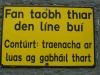
Broithe Posted March 24, 2024 Author Posted March 24, 2024 Ah, I noticed this sign at the hotel car park entrance today. https://www.google.com/maps/@52.9075934,-7.3528357,3a,15y,164.98h,88.15t/data=!3m7!1e1!3m5!1sIwP4AZGTZTHIR5TNybt5zw!2e0!6shttps:%2F%2Fstreetviewpixels-pa.googleapis.com%2Fv1%2Fthumbnail%3Fpanoid%3DIwP4AZGTZTHIR5TNybt5zw%26cb_client%3Dsearch.revgeo_and_fetch.gps%26w%3D96%26h%3D64%26yaw%3D29.58199%26pitch%3D0%26thumbfov%3D100!7i16384!8i8192?entry=ttu Also 'in context' with the historical location, but I doubt there was ever a level crossing there. I would presume that, with the closure being 60+ years ago, the current 'flat route' of the road' adjacent to the old bridge, would have been implemented after that point, as the practicalities became easier and the bridge became a bit 'tight' for the level of traffic at the time.
LNERW1 Posted June 16, 2024 Posted June 16, 2024 Funny, im reading this sat ~100m from the alignment of the old line just outside the station. 1
Broithe Posted June 28, 2024 Author Posted June 28, 2024 Talk of the Killamuck Bog Trail reminded me that I found this video the other day, recorded under the skew bridge on the Rathdowney & Templemore road, by the old station house.
Broithe Posted April 13, 2025 Author Posted April 13, 2025 The walking group had a local venture today, to gain a few new victims, around Abbeyleix Bog. I spotted these relics at the coffee shop in the hotel carpark. 5
Recommended Posts
Create an account or sign in to comment
You need to be a member in order to leave a comment
Create an account
Sign up for a new account in our community. It's easy!
Register a new accountSign in
Already have an account? Sign in here.
Sign In Now