leslie10646 Posted March 11, 2018 Posted March 11, 2018 Hats off to you Tin Tin - what an interesting prototype to try! I was going to ask you if you were including the remains of Brunel's attempt at building the line, but then I noticed an unused tunnel, so you have? Great attention to detail. Congrats. The retaining wall for the road is a work of art. Re Bray station - using old points can be a headache (I've got boxes full of them). Make sure they work before you lay them! Sometimes biting the bullet and buying a new one is a better tactic. Are you going to electrify it? Shall we see one of Eoin's DARTs going through it!
TinTin Posted March 11, 2018 Author Posted March 11, 2018 Thank you Leslie .ive been collecting 00 trains for many years . And this layout is only my second attempt at a railway .My last attempet had mountains but not at this scale . N scale would be best to fit all aspects in . Brunel’s tunnel with bridges ,, wooden trestles would be nice,i was thinking to make the bridges to put in place as they would have stood. The track way and walk way has many tunnels ,bridges , arches , and patch up walls up rights ...concrete patch ups over the years . . Can I ask for some help in finding out what a structure of blocks on the south bank . Find picture .. on the wall below there is a opening. I think it was a make shift crane myself I could be wrong . If you look closely it is on the what was the track bed . Any help in this will be very greatful . With thanks to YouTube for photo ..
TinTin Posted April 7, 2018 Author Posted April 7, 2018 Sorry for the Wait . Need help in finding what structure on the south bank . I think it might have been a crane . If anybody can help it would be great help . 1 2
TinTin Posted April 8, 2018 Author Posted April 8, 2018 30 minutes ago, TinTin said: Thanks guys . Moving very slow but getting there . Still cant find what the structure is on the south bank but I keep looking lol.
Glenderg Posted April 8, 2018 Posted April 8, 2018 If this is the location on google maps, they appear to be two remnants of piers for a bridge. I've guesstimated the old alignment on the 1948 O.S. Maps and it appears to line up. (Holding down CTRL whilst in google maps allows free orbiting or the camera.) 1 1
murrayec Posted April 8, 2018 Posted April 8, 2018 (edited) Hi Guys That's the remnants of Burnel's 2 trestle timber bridge spanning the Brandy Hole Ravine, I reckon. In 1867 a train with passengers crashed off the bridge into the ravine due to poor track maintenance, 2 died and many were injured Here is a link to a engraving picture, an artist impression of after the accident;-https://www.magnoliabox.com/products/bray-head-ireland-1867-scene-of-the-accident-on-the-dublin-wicklow-and-wenford-railway-kerry-liszt-060430-0678 Eoin Edited April 8, 2018 by murrayec
TinTin Posted April 8, 2018 Author Posted April 8, 2018 (edited) 9 hours ago, Glenderg said: If this is the location on google maps, they appear to be two remnants of piers for a bridge. I've guesstimated the old alignment on the 1948 O.S. Maps and it appears to line up. (Holding down CTRL whilst in google maps allows free orbiting or the camera.) 4 minutes ago, TinTin said: Sorry lads 12 o’clock the square block of concrete it’s to high to be part of bridge . Look closely at it and front wall has a window efect . I still think it was some kind of make shift crane , but when did it appear ? Edited April 8, 2018 by TinTin
murrayec Posted April 9, 2018 Posted April 9, 2018 Hi TinTin If you look at the image I referenced above, on the South side of the bridge one can see a square platform under the track-way a short distance from the ravine edge, also on the Northern side note a small trestle supporting the track-way above the ravine edge- so the track-way seems to have been elevated above the structures of the ravine and the ground level If it was a crane structure! it would have been built after the new line was complete, it could not have been built before because the old line was repaired and used while the new stuff was been built! Why would they use a crane to take stuff up from the sea (if that's what your thinking) when they have the existing track to bring materials in, and risk of boats founding on the rocks below! There is another photo, worth a look, of the bridge after the accident- page 20 of 'Tales of the Permanent Way' by Michael Barry. The author dates the accident in 1865, it also indicates that the track on that side was raised, it also indicates how much artistic licence was used in the engraving image! Eoin
TinTin Posted April 9, 2018 Author Posted April 9, 2018 On 8/4/2018 at 11:46 AM, TinTin said: Thanks guys . Moving very slow but getting there
TinTin Posted April 9, 2018 Author Posted April 9, 2018 Thank you for that detail .yes it was mad of me to think it was a crane . Loads from the sea bye boat . Should have known better . But .......the train came off the other bridge ,on the other side south of the old tunnel . Correct me if I’m wrong .. I thought . And only heard about one such crash . If you would take a look at what I found long ago . Thanks to YouTube .m looks closely and you can see the shapes of the rock forms and the angles . I thank you again .and can’t Waite for your reply . Cause that square is really making my brain hurt lol.. cheers Tintin
Broithe Posted April 9, 2018 Posted April 9, 2018 I wondered if they might be the tops of the central piers that were removed for safety, but they seem to be joined at the landward side - and the peirs don't look to have been that high, anyway. There does seem to be a sort of drainage slot below and in line with them, though.
TinTin Posted April 9, 2018 Author Posted April 9, 2018 GLad to have you on board Broithe. Got you thinking . I have studied most craves on most of the rocks . For a moment I tough you might be right . Thanks for your input . 1
murrayec Posted April 9, 2018 Posted April 9, 2018 Hi TinTin The accident was reported to have happened at the 'Brandy Hole ravine', as far as I'm aware the location we are discussing is the Brandy Hole? this is going by local history, I also assumed this was the only cove that had boat landing and access up the head by a ravine for the smugglers When I first saw the wood-cut image I saw it as this ravine, in discussion, and not further South, but looking at the three images you posted has helped me to understand the photo in the Permanent Way book- the third image is the same as in the book, the rocks always puzzled me- the rock formation on the sea side lines up with the rocks in the other two images! This is a link to a report on the accident in the Freeman's Journal, 10 August 1867 http://www.greystonesahs.org/gahs1/index.php?id=386 Eoin 1
waffles Posted May 2, 2018 Posted May 2, 2018 Bray turntable was 45ft long water tower held over 40.000 Gallons of water and a coaling stage as well locos were watered under it.
TinTin Posted May 2, 2018 Author Posted May 2, 2018 Ah that's great waffles . That' some tower . If I can find close up photos of it and the table I could crack on . Laying track for the rest of the station at the moment wire for dcc . 17 points . Loving it now it' falling into place . Thanks very much great help .
TinTin Posted September 7, 2018 Author Posted September 7, 2018 Thanks David . Have been working hard and no time to do much . hopfully some time is coming my way.
Glover Posted January 13, 2019 Posted January 13, 2019 Bray loco shed ? Nice job. The layout of the loco yard at Bray would make an interesting little project on its own. The turntable was on the other side of the mainline, on the goods shed side. Glover
TinTin Posted January 13, 2019 Author Posted January 13, 2019 I have all the track down and have been testing . Space for station is very tight In 00 scale the rail crossing is as far as I can go before turning . I have been trying to get photos of the water tower at turn table ,but there is always a engine in the shot lol. I might have to make turn table . I have 16 x 11 should have gone the full 20x 11
jhb171achill Posted January 13, 2019 Posted January 13, 2019 I think those large blocks on the old alignment were something to do with some sort or wartime* observation structure. (* sorry, "emergency"!)
TinTin Posted January 13, 2019 Author Posted January 13, 2019 As you can see in photos im happy with progress if it is a bit slow lol. But it’s getting there . I do believe it’s the best hobby in the world .....my world that is . I must say the DCC wiring was a learning curve . But I got the hang of it in the end with the help of the N.C.E pro cab . 2
David Holman Posted January 14, 2019 Posted January 14, 2019 Interesting to see what the rest of the layout looks like. If it ends up as good as the coastal section, then it will be quite something.
TinTin Posted January 15, 2019 Author Posted January 15, 2019 Water tower started . Not enough hours in the day lol. Can’t Waite for tomorrow . 3
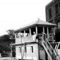
TinTin Posted June 1, 2019 Author Posted June 1, 2019 It's has been awhile . Only getting small amounts of time Mostly late at night . Bray signal box . 10
TinTin Posted June 1, 2019 Author Posted June 1, 2019 Little bit to do . Tidy and inside . . Just a note I used Metcalfe wall sheets For roof tiles and they seem to work . Thanks for likes . Will put up more photos later today. 1
TinTin Posted June 7, 2019 Author Posted June 7, 2019 25B8D2F0-05D1-4F82-B587-43D7188326AE.MOV 25B8D2F0-05D1-4F82-B587-43D7188326AE.MOV Listen to the rumble of a train coming . I think I got the sound right ,lol 4
Recommended Posts
Create an account or sign in to comment
You need to be a member in order to leave a comment
Create an account
Sign up for a new account in our community. It's easy!
Register a new accountSign in
Already have an account? Sign in here.
Sign In Now